The wildlife corridors of tropical north Queensland exist more as a patchwork of necessity than as any continuous, protected pathway. After spending years moving through this landscape – tracking species movement, observing habitat fragmentation, and watching how animals navigate the real world rather than the idealized maps – I’ve come to understand that these corridors are less about grand conservation plans and more about the practical reality of how animals survive in a landscape that’s been substantially altered by human settlement, agriculture, and development.
The region stretches from Cooktown south to around Townsville, encompassing rainforest, eucalypt woodland, grassland, and the transitional zones between them. What makes this area ecologically significant is the sheer concentration of species found nowhere else on Earth. The cassowary, the northern quokka, various tree kangaroos, and countless bird and reptile species depend on being able to move between habitat patches. But the corridors they use aren’t always obvious, and they’re certainly not always protected.
When you actually walk these landscapes, you notice something quickly: animals aren’t waiting for humans to create perfect corridors. They’re using whatever routes remain available. A strip of vegetation along a creek bed becomes a highway for small mammals. A line of scattered trees crossing open farmland serves as a bridge for arboreal species. The eucalypt woodlands that many people overlook as “degraded” or “secondary” habitat often function as critical connectors between the more celebrated rainforest patches.
How Fragmentation Changes Movement Patterns
The fragmentation of tropical north Queensland’s habitat happened gradually, then suddenly. Early clearing for agriculture and settlement created isolated pockets of intact vegetation. Over time, roads, fences, and further land use changes made these pockets even more isolated. What I’ve observed repeatedly is that animals respond to fragmentation not with dramatic behavioral changes, but with subtle shifts in range, timing, and risk tolerance.
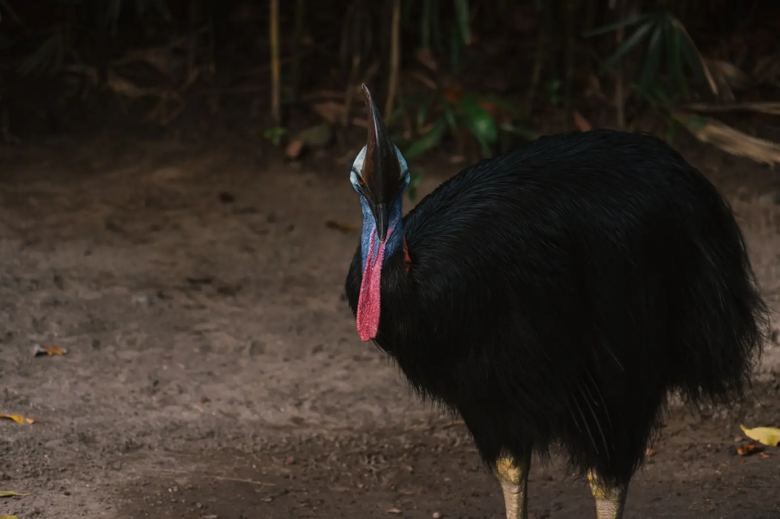
Cassowaries, for instance, have adapted to moving through human-modified landscapes more than they did historically. They cross roads at night, they forage in gardens and disturbed areas, and they’ve expanded their tolerance for proximity to human activity. This isn’t adaptation in the sense of thriving – it’s adaptation in the sense of survival under constraint. The birds still prefer intact rainforest, but they’ll use whatever corridor exists because the alternative is starvation or inability to breed.
Smaller species face different pressures. Tree kangaroos need continuous canopy, which means they’re far more restricted by fragmentation than larger, more mobile animals. I’ve watched populations become increasingly isolated in specific rainforest patches, with little realistic chance of genetic exchange with other populations. The corridor that might work for a cassowary is useless for a tree kangaroo that can’t descend to the ground and cross open space.
The timing of movement also shifts. Animals that historically moved throughout the day now concentrate their activity in early morning and late evening, avoiding the heat and human activity. This temporal shift is a form of corridor use that’s often invisible in conservation planning but critical to understand. A road that’s quiet at dawn is a functional corridor; the same road during midday traffic is a barrier.
What the Corridors Actually Look Like
The most functional corridors I’ve observed tend to follow water. Creeks and river systems, even when heavily modified by clearing on either side, maintain enough vegetation to serve as movement routes. The riparian vegetation provides shade, water access, and food sources. Species follow these waterways because they’re predictable, relatively safe, and usually connect larger habitat patches. The Barron River system, the Mossman River, and various creeks feeding into the Daintree have this function, though their effectiveness varies dramatically depending on current land management upstream.
Road verges and fence lines also function as corridors, though less reliably. A line of native trees retained along a property boundary can allow movement between patches. Conversely, cleared verges and manicured fencing eliminate even these marginal routes. I’ve noticed that older properties in the region often have better corridor function simply because they were cleared before modern agricultural practices standardized the removal of all non-productive vegetation.
The eucalypt woodlands deserve particular mention because they’re often undervalued in corridor planning. These aren’t rainforest, and they’ve been modified by clearing, fire management, and grazing. But they connect rainforest patches and provide habitat for species that can tolerate more open conditions. For ground-dwelling species like wallabies and bandicoots, these woodlands are essential corridors. For arboreal species, they’re less useful, but they still provide occasional tree cover and food sources that facilitate movement.
The Reality of Protection and Management
Protected areas in tropical north Queensland are numerous on paper. National parks, nature reserves, and private conservation areas form a network that, in theory, should protect critical habitat and corridors. The reality is messier. Some protected areas are effectively managed with adequate funding and staffing. Others exist as paper designations with minimal on-ground management. The corridors between protected areas are often unprotected, and their function depends entirely on the goodwill and land management practices of private landholders.
I’ve worked with landholders who actively maintain corridors on their property, retaining native vegetation specifically to allow wildlife movement. I’ve also worked with landholders who, despite good intentions, have no capacity to manage corridors because they’re focused on immediate economic survival. There’s no simple solution here. Conservation funding is limited, and asking a farmer to forgo productive land use for corridor maintenance is asking them to subsidize conservation with their own resources.
The most effective corridor management I’ve seen involves a combination of factors: secure tenure (landholders need confidence they won’t be forced to clear), modest financial incentives, technical support for native vegetation management, and realistic expectations about what can be achieved. A corridor doesn’t need to be pristine. It needs to be passable and to provide enough resources to keep animals moving.
Specific Challenges in the Tropical North
The climate of tropical north Queensland creates specific corridor challenges. The wet season brings flooding that can temporarily block movement routes or create new ones. The dry season concentrates animals around water sources, which can increase pressure on corridors leading to reliable water. Fire management is contentious because fire can destroy corridors, but fire exclusion can lead to fuel accumulation and catastrophic fires that are even more destructive.
Cane toads have fundamentally altered predator-prey dynamics in ways that affect corridor use. Species that were once common are now rare, and the corridors they used are less important. Conversely, species that are expanding their range in response to toad presence are using corridors in new ways. The landscape is constantly shifting in response to these biological changes.
Invasive species more broadly complicate corridor function. Weeds can choke out native vegetation in corridors, making them impassable. Feral pigs destroy understory vegetation and create disturbance that favors weeds. Feral cats hunt small mammals that use corridors. None of these problems have simple solutions, and managing corridors often means managing multiple invasive species simultaneously, which requires resources that are frequently unavailable.
The reality of wildlife corridors in tropical north Queensland is that they’re fragile, often inadequately protected, and dependent on the collective goodwill and capacity of numerous landholders and agencies. They work, but not optimally. Animals move through the landscape, finding routes where they can, adjusting their behavior to avoid the worst hazards, and persisting despite constraints that would have seemed insurmountable a few decades ago. Understanding how these corridors actually function – not as they should function in theory, but as they do function in practice – is essential for anyone involved in conservation in this region.